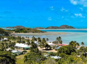
Mabuiag

Mabuiag (formerly known as Jervis Island or traditionally known as Gumu), is an island in the Bellevue Islands, 100km north of Thursday Island. It lies in the Napoleon Passage and Arnolds Passage of Torres Strait.
The people of Mabuiag Island are one of the Melanesian Torres Strait Islander populations. Mabuiag is partly covered with mounds of basaltic rocks, lightly vegetated and mostly well-watered.
Like the larger Moa and Badu Islands to the south, Mabuiag is part of the old, submerged land bridge that ran from Cape York to Papua New Guinea.
Mabuiag Island consists of two moieties:
- The Gumuligal of Wagedagam on the northwest side.
- The Mabuygilgal people of the Paipaidagam on the south-east side.
Location Details
Population
250 residents
Language
The language of the island is the Gœmulgau (Mabuylgau) Ya sub-dialect of Kala Lagaw Ya.
Transport
People can travel to and from the community by fixed wing aircraft (commercial and charter operators), helicopter (charter operators), or by boat (private).
Goods are transported by sea and air freight.
Council office opening hours
Monday to Friday: 9am – 4pm
Council facilities
- Airport
- Council office
- Cultural resource centre
- Outdoor rugby oval
- Undercover basketball court
- Marine infrastructure
Accommodation
| Name | Details | Contact |
|---|---|---|
| Council Accommodation | Motel |
|
| Tagai Primary | 1 x Flat |
Contact Details
Map Road, Mabuiag (Jervis Island), QLD 4875 Australia